


Monte San't Angelo

nave
User

Length
22 km

Max alt
860 m

Uphill gradient
501 m
Km-Effort
29 km

Min alt
461 m

Downhill gradient
502 m
Boucle
Yes
Creation date :
2019-10-26 07:58:20.185
Updated on :
2019-10-26 14:36:50.752
5h46
Difficulty : Medium

FREE GPS app for hiking
 SityTrail
IGN / Geographical institutes
SityTrail Plus
The world is yours!
About
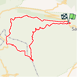
Trail Walking of 22 km to be discovered at Apulia, Foggia, Monte Sant'Angelo. This trail is proposed by nave.
Description
Boucle Monte San't Angelo Ruggiano Abbaye de Pulsano et retour a pied par la route
Positioning
Country:
Italy
Region :
Apulia
Department/Province :
Foggia
Municipality :
Monte Sant'Angelo
Location:
Unknown
Start:(Dec)
Start:(UTM)
578995 ; 4617719 (33T) N.
Comments